
1、labelme标注
当你安装好labelme启动后,open dir开始标注,选择Create Rectangle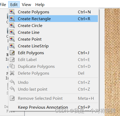
拖拽画框,然后选择类别(没有就直接输入会自动新建),标注好一幅图后点击next image会弹框提示保存json文件,保存即可。
当你将所有图像标注完后,点击Next Image是没有反应的(因为没有Next图了),此时直接x掉labelme软件即可
如果你将json文件保存在图像文件夹中,则应当有以下结构:
- img1.jpg
- img1.json
- img2.jpg
- img2.json
- …
2、转为coco格式
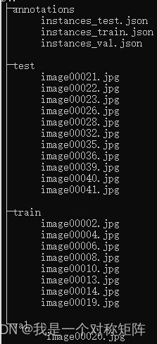
假设我有一个mycoco的数据集,是符合coco2017数据集格式的,那么他的目录结构应该如下,
在mycoco文件夹下有4个文件夹:annotations(存放train、val和test的标注信息)、train(存放train集图片)、val(存放val集图片)、test(存放test集图片)
现在我们已经用labelme标注好的信息,如何转换为上面的coco结构呢?
#!/usr/bin/env python# coding: utf-8# Copyright (c) 2019 PaddlePaddle Authors. All Rights Reserved.## Licensed under the Apache License, Version 2.0 (the "License");# you may not use this file except in compliance with the License.# You may obtain a copy of the License at##     http://www.apache.org/licenses/LICENSE-2.0## Unless required by applicable law or agreed to in writing, software# distributed under the License is distributed on an "AS IS" BASIS,# WITHOUT WARRANTIES OR CONDITIONS OF ANY KIND, either express or implied.# See the License for the specific language governing permissions and# limitations under the License.import argparse
import glob
import json
import os
import os.path as osp
import shutil
import xml.etree.ElementTree as ET

import numpy as np
import PIL.ImageDraw
from tqdm import tqdm
import cv2

label_to_num ={}
categories_list =[]
labels_list =[]classMyEncoder(json.JSONEncoder):defdefault(self, obj):ifisinstance(obj, np.integer):returnint(obj)elifisinstance(obj, np.floating):returnfloat(obj)elifisinstance(obj, np.ndarray):return obj.tolist()else:returnsuper(MyEncoder, self).default(obj)defimages_labelme(data, num):
    image ={}
    image['height']= data['imageHeight']
    image['width']= data['imageWidth']
    image['id']= num +1if'\\'in data['imagePath']:
        image['file_name']= data['imagePath'].split('\\')[-1]else:
        image['file_name']= data['imagePath'].split('/')[-1]return image

defimages_cityscape(data, num, img_file):
    image ={}
    image['height']= data['imgHeight']
    image['width']= data['imgWidth']
    image['id']= num +1
    image['file_name']= img_file
    return image

defcategories(label, labels_list):
    category ={}
    category['supercategory']='component'
    category['id']=len(labels_list)+1
    category['name']= label
    return category

defannotations_rectangle(points, label, image_num, object_num, label_to_num):
    annotation ={}
    seg_points = np.asarray(points).copy()
    seg_points[1,:]= np.asarray(points)[2,:]
    seg_points[2,:]= np.asarray(points)[1,:]
    annotation['segmentation']=[list(seg_points.flatten())]
    annotation['iscrowd']=0
    annotation['image_id']= image_num +1
    annotation['bbox']=list(map(float,[
            points[0][0], points[0][1], points[1][0]- points[0][0], points[1][1]- points[0][1]]))
    annotation['area']= annotation['bbox'][2]* annotation['bbox'][3]
    annotation['category_id']= label_to_num[label]
    annotation['id']= object_num +1return annotation

defannotations_polygon(height, width, points, label, image_num, object_num,
                        label_to_num):
    annotation ={}
    annotation['segmentation']=[list(np.asarray(points).flatten())]
    annotation['iscrowd']=0
    annotation['image_id']= image_num +1
    annotation['bbox']=list(map(float, get_bbox(height, width, points)))
    annotation['area']= annotation['bbox'][2]* annotation['bbox'][3]
    annotation['category_id']= label_to_num[label]
    annotation['id']= object_num +1return annotation

defget_bbox(height, width, points):
    polygons = points
    mask = np.zeros([height, width], dtype=np.uint8)
    mask = PIL.Image.fromarray(mask)
    xy =list(map(tuple, polygons))
    PIL.ImageDraw.Draw(mask).polygon(xy=xy, outline=1, fill=1)
    mask = np.array(mask, dtype=bool)
    index = np.argwhere(mask ==1)
    rows = index[:,0]
    clos = index[:,1]
    left_top_r = np.min(rows)
    left_top_c = np.min(clos)
    right_bottom_r = np.max(rows)
    right_bottom_c = np.max(clos)return[
        left_top_c, left_top_r, right_bottom_c - left_top_c,
        right_bottom_r - left_top_r
    ]defdeal_json(ds_type, img_path, json_path):
    data_coco ={}
    images_list =[]
    annotations_list =[]
    image_num =-1
    object_num =-1for img_file in os.listdir(img_path):
        img_label = os.path.splitext(img_file)[0]if img_file.split('.')[-1]notin['bmp','jpg','jpeg','png','JPEG','JPG','PNG']:continue
        label_file = osp.join(json_path, img_label +'.json')print('Generating dataset from:', label_file)
        image_num = image_num +1withopen(label_file)as f:
            data = json.load(f)if ds_type =='labelme':
                images_list.append(images_labelme(data, image_num))elif ds_type =='cityscape':
                images_list.append(images_cityscape(data, image_num, img_file))if ds_type =='labelme':for shapes in data['shapes']:
                    object_num = object_num +1
                    label = shapes['label']if label notin labels_list:
                        categories_list.append(categories(label, labels_list))
                        labels_list.append(label)
                        label_to_num[label]=len(labels_list)
                    p_type = shapes['shape_type']if p_type =='polygon':
                        points = shapes['points']
                        annotations_list.append(
                            annotations_polygon(data['imageHeight'], data['imageWidth'], points, label, image_num,
                                                object_num, label_to_num))if p_type =='rectangle':(x1, y1),(x2, y2)= shapes['points']
                        x1, x2 =sorted([x1, x2])
                        y1, y2 =sorted([y1, y2])
                        points =[[x1, y1],[x2, y2],[x1, y2],[x2, y1]]
                        annotations_list.append(
                            annotations_rectangle(points, label, image_num,
                                                  object_num, label_to_num))elif ds_type =='cityscape':for shapes in data['objects']:
                    object_num = object_num +1
                    label = shapes['label']if label notin labels_list:
                        categories_list.append(categories(label, labels_list))
                        labels_list.append(label)
                        label_to_num[label]=len(labels_list)
                    points = shapes['polygon']
                    annotations_list.append(
                        annotations_polygon(data['imgHeight'], data['imgWidth'], points, label, image_num, object_num,
                                            label_to_num))
    data_coco['images']= images_list
    data_coco['categories']= categories_list
    data_coco['annotations']= annotations_list
    return data_coco

defvoc_get_label_anno(ann_dir_path, ann_ids_path, labels_path):withopen(labels_path,'r')as f:
        labels_str = f.read().split()
    labels_ids =list(range(1,len(labels_str)+1))withopen(ann_ids_path,'r')as f:
        ann_ids =[lin.strip().split(' ')[-1]for lin in f.readlines()]

    ann_paths =[]for aid in ann_ids:if aid.endswith('xml'):
            ann_path = os.path.join(ann_dir_path, aid)else:
            ann_path = os.path.join(ann_dir_path, aid +'.xml')
        ann_paths.append(ann_path)returndict(zip(labels_str, labels_ids)), ann_paths

defvoc_get_image_info(annotation_root, im_id):
    filename = annotation_root.findtext('filename')assert filename isnotNone
    img_name = os.path.basename(filename)

    size = annotation_root.find('size')
    width =float(size.findtext('width'))
    height =float(size.findtext('height'))

    image_info ={'file_name': filename,'height': height,'width': width,'id': im_id
    }return image_info

defvoc_get_coco_annotation(obj, label2id):
    label = obj.findtext('name')assert label in label2id,"label is not in label2id."
    category_id = label2id[label]
    bndbox = obj.find('bndbox')
    xmin =float(bndbox.findtext('xmin'))
    ymin =float(bndbox.findtext('ymin'))
    xmax =float(bndbox.findtext('xmax'))
    ymax =float(bndbox.findtext('ymax'))assert xmax > xmin and ymax > ymin,"Box size error."
    o_width = xmax - xmin
    o_height = ymax - ymin
    anno ={'area': o_width * o_height,'iscrowd':0,'bbox':[xmin, ymin, o_width, o_height],'category_id': category_id,'ignore':0,}return anno

defvoc_xmls_to_cocojson(annotation_paths, label2id, output_dir, output_file):
    output_json_dict ={"images":[],"type":"instances","annotations":[],"categories":[]}
    bnd_id =1# bounding box start id
    im_id =0print('Start converting !')for a_path in tqdm(annotation_paths):# Read annotation xml
        ann_tree = ET.parse(a_path)
        ann_root = ann_tree.getroot()

        img_info = voc_get_image_info(ann_root, im_id)
        output_json_dict['images'].append(img_info)for obj in ann_root.findall('object'):
            ann = voc_get_coco_annotation(obj=obj, label2id=label2id)
            ann.update({'image_id': im_id,'id': bnd_id})
            output_json_dict['annotations'].append(ann)
            bnd_id = bnd_id +1
        im_id +=1for label, label_id in label2id.items():
        category_info ={'supercategory':'none','id': label_id,'name': label}
        output_json_dict['categories'].append(category_info)
    output_file = os.path.join(output_dir, output_file)withopen(output_file,'w')as f:
        output_json = json.dumps(output_json_dict)
        f.write(output_json)defwiderface_to_cocojson(root_path):
    train_gt_txt = os.path.join(root_path,"wider_face_split","wider_face_train_bbx_gt.txt")
    val_gt_txt = os.path.join(root_path,"wider_face_split","wider_face_val_bbx_gt.txt")
    train_img_dir = os.path.join(root_path,"WIDER_train","images")
    val_img_dir = os.path.join(root_path,"WIDER_val","images")assert train_gt_txt
    assert val_gt_txt
    assert train_img_dir
    assert val_img_dir
    save_path = os.path.join(root_path,"widerface_train.json")
    widerface_convert(train_gt_txt, train_img_dir, save_path)print("Wider Face train dataset converts sucess, the json path: {}".format(save_path))
    save_path = os.path.join(root_path,"widerface_val.json")
    widerface_convert(val_gt_txt, val_img_dir, save_path)print("Wider Face val dataset converts sucess, the json path: {}".format(save_path))defwiderface_convert(gt_txt, img_dir, save_path):
    output_json_dict ={"images":[],"type":"instances","annotations":[],"categories":[{'supercategory':'none','id':0,'name':"human_face"}]}
    bnd_id =1# bounding box start id
    im_id =0print('Start converting !')withopen(gt_txt)as fd:
        lines = fd.readlines()

    i =0while i <len(lines):
        image_name = lines[i].strip()
        bbox_num =int(lines[i +1].strip())
        i +=2
        img_info = get_widerface_image_info(img_dir, image_name, im_id)if img_info:
            output_json_dict["images"].append(img_info)for j inrange(i, i + bbox_num):
                anno = get_widerface_ann_info(lines[j])
                anno.update({'image_id': im_id,'id': bnd_id})
                output_json_dict['annotations'].append(anno)
                bnd_id +=1else:print("The image dose not exist: {}".format(os.path.join(img_dir, image_name)))
        bbox_num =1if bbox_num ==0else bbox_num
        i += bbox_num
        im_id +=1withopen(save_path,'w')as f:
        output_json = json.dumps(output_json_dict)
        f.write(output_json)defget_widerface_image_info(img_root, img_relative_path, img_id):
    image_info ={}
    save_path = os.path.join(img_root, img_relative_path)if os.path.exists(save_path):
        img = cv2.imread(save_path)
        image_info["file_name"]= os.path.join(os.path.basename(
            os.path.dirname(img_root)), os.path.basename(img_root),
            img_relative_path)
        image_info["height"]= img.shape[0]
        image_info["width"]= img.shape[1]
        image_info["id"]= img_id
    return image_info

defget_widerface_ann_info(info):
    info =[int(x)for x in info.strip().split()]
    anno ={'area': info[2]* info[3],'iscrowd':0,'bbox':[info[0], info[1], info[2], info[3]],'category_id':0,'ignore':0,'blur': info[4],'expression': info[5],'illumination': info[6],'invalid': info[7],'occlusion': info[8],'pose': info[9]}return anno

defmain():
    parser = argparse.ArgumentParser(
        formatter_class=argparse.ArgumentDefaultsHelpFormatter)
    parser.add_argument('--dataset_type',help='the type of dataset, can be `voc`, `widerface`, `labelme` or `cityscape`')
    parser.add_argument('--json_input_dir',help='input annotated directory')
    parser.add_argument('--image_input_dir',help='image directory')
    parser.add_argument('--output_dir',help='output dataset directory', default='./')
    parser.add_argument('--train_proportion',help='the proportion of train dataset',type=float,
        default=1.0)
    parser.add_argument('--val_proportion',help='the proportion of validation dataset',type=float,
        default=0.0)
    parser.add_argument('--test_proportion',help='the proportion of test dataset',type=float,
        default=0.0)
    parser.add_argument('--voc_anno_dir',help='In Voc format dataset, path to annotation files directory.',type=str,
        default=None)
    parser.add_argument('--voc_anno_list',help='In Voc format dataset, path to annotation files ids list.',type=str,
        default=None)
    parser.add_argument('--voc_label_list',help='In Voc format dataset, path to label list. The content of each line is a category.',type=str,
        default=None)
    parser.add_argument('--voc_out_name',type=str,
        default='voc.json',help='In Voc format dataset, path to output json file')
    parser.add_argument('--widerface_root_dir',help='The root_path for wider face dataset, which contains `wider_face_split`, `WIDER_train` and `WIDER_val`.And the json file will save in this path',type=str,
        default=None)
    args = parser.parse_args()try:assert args.dataset_type in['voc','labelme','cityscape','widerface']except AssertionError as e:print('Now only support the voc, cityscape dataset and labelme dataset!!')
        os._exit(0)if args.dataset_type =='voc':assert args.voc_anno_dir and args.voc_anno_list and args.voc_label_list
        label2id, ann_paths = voc_get_label_anno(
            args.voc_anno_dir, args.voc_anno_list, args.voc_label_list)
        voc_xmls_to_cocojson(
            annotation_paths=ann_paths,
            label2id=label2id,
            output_dir=args.output_dir,
            output_file=args.voc_out_name)elif args.dataset_type =="widerface":assert args.widerface_root_dir
        widerface_to_cocojson(args.widerface_root_dir)else:try:assert os.path.exists(args.json_input_dir)except AssertionError as e:print('The json folder does not exist!')
            os._exit(0)try:assert os.path.exists(args.image_input_dir)except AssertionError as e:print('The image folder does not exist!')
            os._exit(0)try:assertabs(args.train_proportion + args.val_proportion \
                    + args.test_proportion -1.0)<1e-5except AssertionError as e:print('The sum of pqoportion of training, validation and test datase must be 1!')
            os._exit(0)# Allocate the dataset.
        total_num =len(glob.glob(osp.join(args.json_input_dir,'*.json')))if args.train_proportion !=0:
            train_num =int(total_num * args.train_proportion)
            out_dir = args.output_dir +'/train'ifnot os.path.exists(out_dir):
                os.makedirs(out_dir)else:
            train_num =0if args.val_proportion ==0.0:
            val_num =0
            test_num = total_num - train_num
            out_dir = args.output_dir +'/test'if args.test_proportion !=0.0andnot os.path.exists(out_dir):
                os.makedirs(out_dir)else:
            val_num =int(total_num * args.val_proportion)
            test_num = total_num - train_num - val_num
            val_out_dir = args.output_dir +'/val'ifnot os.path.exists(val_out_dir):
                os.makedirs(val_out_dir)
            test_out_dir = args.output_dir +'/test'if args.test_proportion !=0.0andnot os.path.exists(test_out_dir):
                os.makedirs(test_out_dir)
        count =1for img_name in os.listdir(args.image_input_dir):if count <= train_num:if osp.exists(args.output_dir +'/train/'):
                    shutil.copyfile(
                        osp.join(args.image_input_dir, img_name),
                        osp.join(args.output_dir +'/train/', img_name))else:if count <= train_num + val_num:if osp.exists(args.output_dir +'/val/'):
                        shutil.copyfile(
                            osp.join(args.image_input_dir, img_name),
                            osp.join(args.output_dir +'/val/', img_name))else:if osp.exists(args.output_dir +'/test/'):
                        shutil.copyfile(
                            osp.join(args.image_input_dir, img_name),
                            osp.join(args.output_dir +'/test/', img_name))
            count = count +1# Deal with the json files.ifnot os.path.exists(args.output_dir +'/annotations'):
            os.makedirs(args.output_dir +'/annotations')if args.train_proportion !=0:
            train_data_coco = deal_json(args.dataset_type,
                                        args.output_dir +'/train',
                                        args.json_input_dir)
            train_json_path = osp.join(args.output_dir +'/annotations','instance_train.json')
            json.dump(
                train_data_coco,open(train_json_path,'w'),
                indent=4,
                cls=MyEncoder)if args.val_proportion !=0:
            val_data_coco = deal_json(args.dataset_type,
                                      args.output_dir +'/val',
                                      args.json_input_dir)
            val_json_path = osp.join(args.output_dir +'/annotations','instance_val.json')
            json.dump(
                val_data_coco,open(val_json_path,'w'),
                indent=4,
                cls=MyEncoder)if args.test_proportion !=0:
            test_data_coco = deal_json(args.dataset_type,
                                       args.output_dir +'/test',
                                       args.json_input_dir)
            test_json_path = osp.join(args.output_dir +'/annotations','instance_test.json')
            json.dump(
                test_data_coco,open(test_json_path,'w'),
                indent=4,
                cls=MyEncoder)if __name__ =='__main__':"""
    python tools/x2coco.py \
                --dataset_type labelme \
                --json_input_dir ./labelme_annos/ \
                --image_input_dir ./labelme_imgs/ \
                --output_dir ./mycoco/ \
                --train_proportion 0.8 \
                --val_proportion 0.2 \
                --test_proportion 0.0
    """
    main()
上面的代码是从paddledetection拿来的(不得不说百度的的小脚本还是挺多的),通过命令行参数:
python tools/x2coco.py \
            --dataset_type labelme \
            --json_input_dir ./labelme_annos/ \
            --image_input_dir ./labelme_imgs/ \
            --output_dir ./mycoco/ \
            --train_proportion 0.8\
            --val_proportion 0.2\
            --test_proportion 0.0
- dataset_type:是将labelme转为coco,锁着这里默认就是labelme
- json_input_dir:指向labelme的json文件所在路径
- image_input_dir:指向labelme的img文件所在路径(在这里json和img都是相同的路径)
- output_dir :转为coco后输出的文件夹路径
- train_proportion、val_proportion、test_proportion:划分数据集比例,总之三者之和必须为1
成功执行后就能看到mycoco文件夹: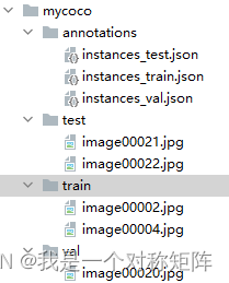
注意:虽然现在目录结构上和coco一致了,但是在很多开源目标检测项目中,默认的文件名字不太一样,比如有的文件夹为train2017、val2017和test2017,或者annotations中的文件名为instances_train.json(多了一个s),请结合实际情况修改即可
3、标签可视化
经过labelme的标注和转为coco格式后,我们希望可视化coco数据集,可以使用以下代码:
import cv2
import os
from pycocotools.coco import COCO

labels=['eye','noise','mouth']# 分类标签名
img_path ='mycoco/train'# 比如我需要可视化train集
annFile ='mycoco/annotations\instances_train.json'# 指定train集的json文件
save_path ='mycoco/train_vis'# 可视化结果的保存路径ifnot os.path.exists(save_path):
    os.makedirs(save_path)defdraw_rectangle(coordinates, image, image_name,color=(0,255,0),thickness=1,fontScale=0.5):"""

    @param coordinates: 所有框的信息[[left,top,right,bottom],[left,top,right,bottom],...]
    @param image:
    @param image_name:
    @param color: 框和文字的颜色,默认绿色
    @param thickness: 框线条的粗细
    @param fontScale: 字体大小
    @return:
    """for coordinate in coordinates:# 遍历每一个框信息
        left, top, right, bottom =map(int, coordinate[:-1])
        label=coordinate[-1]
        cv2.rectangle(image,(left, top),(right, bottom), color, thickness)
        cv2.putText(image,str(label),(left, top), cv2.FONT_HERSHEY_SIMPLEX, fontScale, color, thickness)

    cv2.imwrite(save_path +'/'+ image_name, image)

coco = COCO(annFile)
imgIds = coco.getImgIds()# 获取每张图片的序号for imgId in imgIds:
    img = coco.loadImgs(imgId)[0]#加载图片信息
    image_name = img['file_name']# 获取图片名字
    annIds = coco.getAnnIds(imgIds=img['id'], catIds=[], iscrowd=None)# 根据图片id获取与该id相关联的anno的序号
    anns = coco.loadAnns(annIds)# 根据anno序号获取anno信息

    coordinates =[]
    img_raw = cv2.imread(os.path.join(img_path, image_name))for j inrange(len(anns)):
        coordinate = anns[j]['bbox']# 遍历每一个anno,获取到框信息,[left,top,width,heigh]
        coordinate[2]+= coordinate[0]# 计算得到right
        coordinate[3]+= coordinate[1]# 计算得到bottom
        coordinate.append(labels[anns[j]['category_id']-1])# 追加分类标签,形成[left,top,right,bottom,label]
        coordinates.append(coordinate)# [[left,top,right,bottom],[left,top,right,bottom],...]

    draw_rectangle(coordinates, img_raw, image_name)
就会得到标注信息绘制后的图: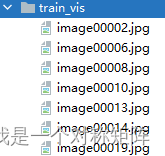
本文转载自: https://blog.csdn.net/qq_40243750/article/details/129843910
版权归原作者 我是一个对称矩阵 所有, 如有侵权,请联系我们删除。
版权归原作者 我是一个对称矩阵 所有, 如有侵权,请联系我们删除。