
一、基础概念
气象数据通常以多种格式存储和交换,以适应不同的应用需求和处理工具。以下是一些常见的气象数据格式及其转换方法的概述:
常见气象数据格式
1. NetCDF(Network Common Data Form):一种自描述、自包含的数据格式,广泛用于存储气象和气候模型输出、观测数据等。NetCDF支持多维度数组、属性和变量,便于跨平台共享。
2. GRIB(GRIdded Binary):主要用于气象预报产品,包括GRIB1和GRIB2两种版本。它以高效的方式存储大量的气象格点数据,如温度、风速等,是气象预报中心之间交换数据的标准格式。
3. HDF(Hierarchical Data Format):类似于NetCDF,支持复杂的数据结构,适用于大规模科学数据集的存储和分发。HDF4和HDF5是两个主要版本。
4. CSV(Comma-Separated Values):简单的文本格式,易于阅读和处理,常用于数据交换,但缺乏自描述性,不包含元数据。
5. GeoTIFF:一种地理空间图像格式,用于存储栅格数据,如卫星图像或气象地图,包含地理坐标信息。
6. BUFR(Binary Universal Form for the Representation of Meteorological Data):国际气象组织推荐的一种二进制编码格式,特别适用于气象观测数据的交换。
数据格式转换方法
1. 使用专业软件:
•Panoply:NASA开发的免费软件,可以打开、查看和转换NetCDF、HDF、GRIB等格式数据。•NCAR Command Language (NCL):提供丰富的脚本语言功能,用于处理NetCDF、GRIB等气象数据。
•GDAL/OGR:开源地理空间库,提供了广泛的格式转换能力,支持NetCDF、HDF、GeoTIFF等格式的转换。
2. 编程语言库:
**•Python: **利用netCDF4, pygrib, h5py等库进行数据读写和格式转换。xarray库提供了更高级的数据结构,方便处理NetCDF和GRIB数据。
•MATLAB:内置了对NetCDF、HDF的读写支持,也可通过第三方工具箱处理其他格式。
•R语言:使用ncdf4、raster、rgdal等包处理NetCDF、GRIB、GeoTIFF等格式。
3. 在线转换工具:
虽然不如上述方法灵活,但存在一些在线工具,允许用户上传文件并转换为不同格式,不过这类工具在处理大型气象数据集时可能受限。进行数据格式转换时,需注意保留数据的完整性和准确性,特别是元数据信息,以确保转换后的数据在后续分析中仍然有效。
二、实践应用
关键代码实现
package com.netcdf.controller;
import com.alibaba.fastjson.JSON;
import com.alibaba.fastjson.JSONArray;
import org.springframework.stereotype.Controller;
import org.springframework.web.bind.annotation.RequestMapping;
import org.springframework.web.bind.annotation.RequestMethod;
import org.springframework.web.bind.annotation.ResponseBody;
import java.util.*;
import static com.netcdf.util.NcUtil.*;
@Controller
@RequestMapping(value = "/ReadGridNc")
public class ReadGridNcData {
//http://localhost:8087/NetcdfServer/ReadGridNc/getNcData?FilePath=20210708_2021070804.nc&FilterBound=&valField=UGRD_10maboveground
/**
*
* @param FilePath
* @param FilterBound
* @param valField
* @return
*/
@RequestMapping(value = "/getNcData", method = RequestMethod.GET)
public @ResponseBody
Map GetNcData(String FilePath,String FilterBound,String valField) {
Map map = AnalysisNC(FilePath, FilterBound,valField,1);
return map;
}
//http://localhost:8087/NetcdfServer/ReadGridNc/GetNcWindData?FilePath=2023042323.grb2
/**
*
* @param FilePath
* @return
*/
@RequestMapping(value = "/GetNcWindData", method = RequestMethod.GET)
public @ResponseBody
JSONArray GetNcWindData(String FilePath) {
String map = AnalysisNcWind(FilePath);
return JSON.parseArray(map);
}
//http://localhost:8088/NetcdfServer/ReadGridNc/getNcDataSurface?FilePath=2022090212.nc&FilterBound=&valField=PRES_surface&intvRanges=0,100000,10005,100010,100015&boundPath=1&isIDW=true&isClip=false
/**
*
* @param FilePath
* @param FilterBound
* @param valField
* @return
*/
@RequestMapping(value = "/getNcDataSurface", method = RequestMethod.GET)
public @ResponseBody
String GetNcDataSurface(String FilePath,String FilterBound,String valField,String intvRanges,String boundPath,boolean isIDW,boolean isClip) {
String[] Ranges=intvRanges.substring(0,intvRanges.length()).split(",");
double[] dataInterval = new double[Ranges.length];
for(int i=0;i<Ranges.length;i++){
dataInterval[i]=Double.valueOf(Ranges[i]);
if( i == 1 && dataInterval[i] == 0.0){
dataInterval[i] = 0.0001;
}
}
Map map = AnalysisNC(FilePath, FilterBound,valField,1);
if(map!=null) {
String strGeojson = nc2EquiSurface(map, dataInterval,isClip,boundPath,isIDW);
return strGeojson;
}
return "";
}
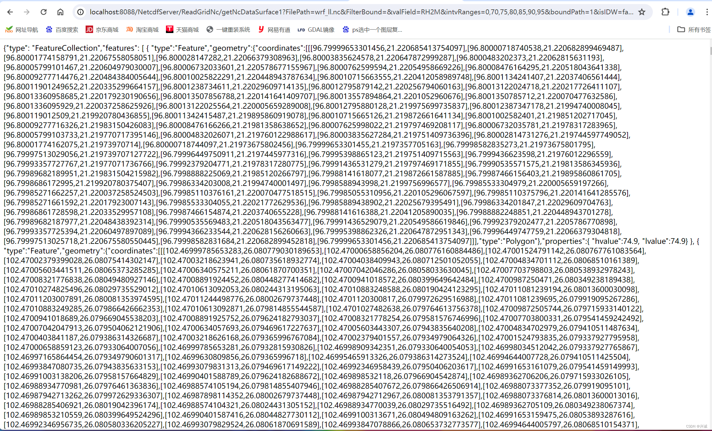
//http://localhost:8088/NetcdfServer/ReadGridNc/getNcDataSurface1?FilePath=wrf_ll.nc&FilterBound=&valField=RH2M&intvRanges=0,100000,10005,100010,100015&boundPath=1&isIDW=true&isClip=false
//http://localhost:8088/NetcdfServer/ReadGridNc/getNcDataSurface1?FilePath=wrf_ll.nc&FilterBound=&valField=RH2M&intvRanges=0,70,75,80,85,90,95&boundPath=1&isIDW=false&isClip=false
/**
*
* @param FilePath
* @param FilterBound
* @param valField
* @return
*/
@RequestMapping(value = "/getNcDataSurface1", method = RequestMethod.GET)
public @ResponseBody
String GetNcDataSurface1(String FilePath,String FilterBound,String valField,String intvRanges,String boundPath,boolean isIDW,boolean isClip) {
String[] Ranges=intvRanges.substring(0,intvRanges.length()).split(",");
double[] dataInterval = new double[Ranges.length];
for(int i=0;i<Ranges.length;i++){
dataInterval[i]=Double.valueOf(Ranges[i]);
if( i == 1 && dataInterval[i] == 0.0){
dataInterval[i] = 0.0001;
}
}
Map map = AnalysisNC1(FilePath, FilterBound,valField,3);
// Map map = AnalysisNC1(FilePath, FilterBound,valField);
if(map!=null) {
String strGeojson = nc2EquiSurface1(map, dataInterval,isClip,boundPath,isIDW);
return strGeojson;
}
return "";
}
//http://localhost:8088/NetcdfServer/ReadGridNc/getNcDataMICPS?FilePath=wrf_ll.nc&FilterBound=&valField=RH2M&intvRanges=0,70,75,80,85,90,95&boundPath=1&isIDW=false&isClip=false
/**
*
* @param FilePath
* @param FilterBound
* @param valField
* @return
*/
@RequestMapping(value = "/getNcDataMICPS", method = RequestMethod.GET)
public @ResponseBody
String GetNcDataMICPS(String FilePath,String FilterBound,String valField,String intvRanges,String boundPath,boolean isIDW,boolean isClip) {
String[] Ranges=intvRanges.substring(0,intvRanges.length()).split(",");
double[] dataInterval = new double[Ranges.length];
for(int i=0;i<Ranges.length;i++){
dataInterval[i]=Double.valueOf(Ranges[i]);
if( i == 1 && dataInterval[i] == 0.0){
dataInterval[i] = 0.0001;
}
}
Map map = AnalysisNC1(FilePath, FilterBound,valField,1);
// Map map = AnalysisNC1(FilePath, FilterBound,valField);
if(map!=null) {
StringBuilder strGeojson = new StringBuilder();
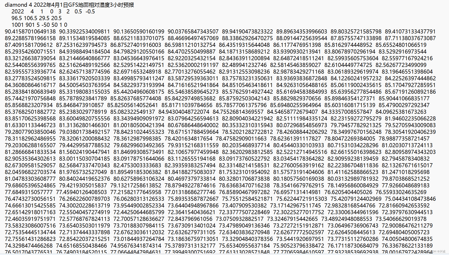
strGeojson.append("diamond 4 2022年4月1日GFS地面相对湿度3小时预报\n" +
" 2022 4 1 0 3 2 0.5 -0.5 \n" +
" 96.5 106.5 29.5 20.5 \n" +
" 1001 901 5 -50 50 1 0\n");
strGeojson.append(map.get("val").toString().replace("[","").replace("]","").replaceAll(","," "));
return strGeojson.toString();
}
return "";
}
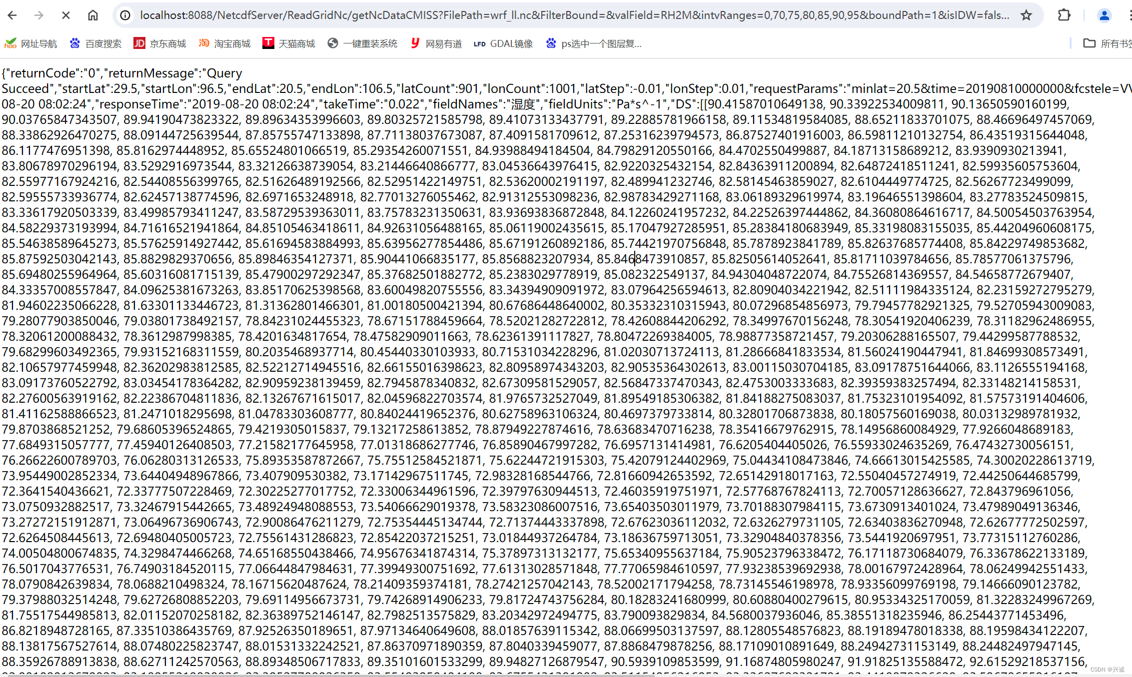
//http://localhost:8088/NetcdfServer/ReadGridNc/getNcDataCMISS?FilePath=wrf_ll.nc&FilterBound=&valField=RH2M&intvRanges=0,70,75,80,85,90,95&boundPath=1&isIDW=false&isClip=false
/**
*
* @param FilePath
* @param FilterBound
* @param valField
* @return
*/
@RequestMapping(value = "/getNcDataCMISS", method = RequestMethod.GET)
public @ResponseBody
String GetNcDataCMISS(String FilePath,String FilterBound,String valField,String intvRanges,String boundPath,boolean isIDW,boolean isClip) {
String[] Ranges=intvRanges.substring(0,intvRanges.length()).split(",");
double[] dataInterval = new double[Ranges.length];
for(int i=0;i<Ranges.length;i++){
dataInterval[i]=Double.valueOf(Ranges[i]);
if( i == 1 && dataInterval[i] == 0.0){
dataInterval[i] = 0.0001;
}
}
Map map = AnalysisNC1(FilePath, FilterBound,valField,1);
// Map map = AnalysisNC1(FilePath, FilterBound,valField);
if(map!=null) {
StringBuilder strGeojson = new StringBuilder();
strGeojson.append("{\"returnCode\":\"0\",\"returnMessage\":\"Query Succeed\",\"startLat\":29.5,\"startLon\":96.5,\"endLat\":20.5,\"endLon\":106.5,\"latCount\":901,\"lonCount\":1001,\"latStep\":-0.01,\"lonStep\":0.01,\"requestParams\":\"minlat=20.5&time=20190810000000&fcstele=VVP&datacode=NAFP_FOR_FTM_HIGH_JAP_NEHE&maxlat=29.5&fcstlevel=850&maxlon=106.5&validtime=0&minlon=96.5\",\"requestTime\":\"2019-08-20 08:02:24\",\"responseTime\":\"2019-08-20 08:02:24\",\"takeTime\":\"0.022\",\"fieldNames\":\"湿度\",\"fieldUnits\":\"Pa*s^-1\",\"DS\":[");
strGeojson.append(map.get("val").toString());
strGeojson.append("]}");
return strGeojson.toString();
}
return "";
}
//http://localhost:8088/NetcdfServer/ReadGridNc/getNcDataSurfaceWind?FilePath=2024050914.nc&FilterBound=&intvRanges=0,2,4,6,8,10&boundPath=1&isIDW=true&isClip=false
/**
*
* @param FilePath
* @param FilterBound
* @param valField
* @return
*/
@RequestMapping(value = "/getNcDataSurfaceWind", method = RequestMethod.GET)
public @ResponseBody
String GetNcDataSurfaceWind(String FilePath,String FilterBound,String valField,String intvRanges,String boundPath,boolean isIDW,boolean isClip) {
String[] Ranges=intvRanges.substring(0,intvRanges.length()).split(",");
double[] dataInterval = new double[Ranges.length];
for(int i=0;i<Ranges.length;i++){
dataInterval[i]=Double.valueOf(Ranges[i]);
if( i == 1 && dataInterval[i] == 0.0){
dataInterval[i] = 0.0001;
}
}
//导出图片
AnalysisNCWindyToPng(FilePath, FilterBound,"UGRD_10maboveground","VGRD_10maboveground");
// Map map = AnalysisNCWindy(FilePath, FilterBound,"UGRD_10maboveground","VGRD_10maboveground");
// if(map!=null) {
// String strGeojson = nc2EquiSurface(map, dataInterval,isClip,boundPath,isIDW);
// return strGeojson;
// }
return "nc";
}
//http://localhost:8088/NetcdfServer/ReadGridNc/getGribDataSurfaceWind?FilePath=2024050914.grb2&FilterBound=&intvRanges=0,1,2,3,4,5,6,7,8,9,10,11,12&boundPath=1&isIDW=true&isClip=false
/**
*
* @param FilePath
* @param FilterBound
* @param valField
* @return
*/
@RequestMapping(value = "/getGribDataSurfaceWind", method = RequestMethod.GET)
public @ResponseBody
String GetGribDataSurfaceWind(String FilePath,String FilterBound,String valField,String intvRanges,String boundPath,boolean isIDW,boolean isClip) {
String[] Ranges=intvRanges.substring(0,intvRanges.length()).split(",");
double[] dataInterval = new double[Ranges.length];
for(int i=0;i<Ranges.length;i++){
dataInterval[i]=Double.valueOf(Ranges[i]);
if( i == 1 && dataInterval[i] == 0.0){
dataInterval[i] = 0.0001;
}
}
//导出图片
// AnalysisNCWindyToPng(FilePath, FilterBound,"UGRD_10maboveground","VGRD_10maboveground");
AnalysisGribWindyToPng(FilePath, FilterBound,"u-component_of_wind_height_above_ground","v-component_of_wind_height_above_ground");
return "grib";
}
}
<!DOCTYPE html>
<html>
<head>

    <title>Layers Control Tutorial - Leaflet</title>

    <meta charset="utf-8" />
    <meta name="viewport" content="width=device-width, initial-scale=1.0">

    <link rel="shortcut icon" type="image/x-icon" href="docs/images/favicon.ico" />

    <link rel="stylesheet" href="https://unpkg.com/[email protected]/dist/leaflet.css" integrity="sha512-xwE/Az9zrjBIphAcBb3F6JVqxf46+CDLwfLMHloNu6KEQCAWi6HcDUbeOfBIptF7tcCzusKFjFw2yuvEpDL9wQ==" crossorigin=""/>
    <script src="https://unpkg.com/[email protected]/dist/leaflet.js" integrity="sha512-gZwIG9x3wUXg2hdXF6+rVkLF/0Vi9U8D2Ntg4Ga5I5BZpVkVxlJWbSQtXPSiUTtC0TjtGOmxa1AJPuV0CPthew==" crossorigin=""></script>

    <style>
        html, body {
            height: 100%;
            margin: 0;
        }
        #map {
            width: 1000px;
            height: 700px;
        }
    </style>

</head>
<body>

<div id='map'></div>

<script>

    var grayscaleLayer= L.tileLayer('http://map.geoq.cn/ArcGIS/rest/services/ChinaOnlineCommunity/MapServer/tile/{z}/{y}/{x}', {id: 'map11',maxZoom: 16,minZoom: 4});

    var map = L.map('map', {
        minZoom: 5,
        maxZoom: 12,
        center: [21, 100],
        zoom: 10,
        zoomDelta: 0.5,//点击+-按钮的放缩刻度尺度,默认值1
        zoomSnap: 0.5,//地图能放缩的zoom的最小刻度尺度,默认值1
        fullscreenControl: false,//全屏控件,不显示
        zoomControl: false,//放大缩小控件,不显示
        attributionControl: false//右下角属性控件,不显示
    });
    map.addLayer(grayscaleLayer);

    var imageBounds = [[20.5, 96.5], [29.41, 106.5]];//图片的经纬度范围,西南角点,东北角点(纬度、经度)
    var imageUrl='pixel_art.png';//图片的地址
    var imageLayer =L.imageOverlay(imageUrl, imageBounds,{opacity:0.8});//opacity是透明度
    map.addLayer(imageLayer);

    //如果imageLayer已经创建,后续只需要切换url即可
    if(imageLayer!=null)
    {
        imageLayer.setUrl(imageUrl);
    }
</script>

</body>
</html>
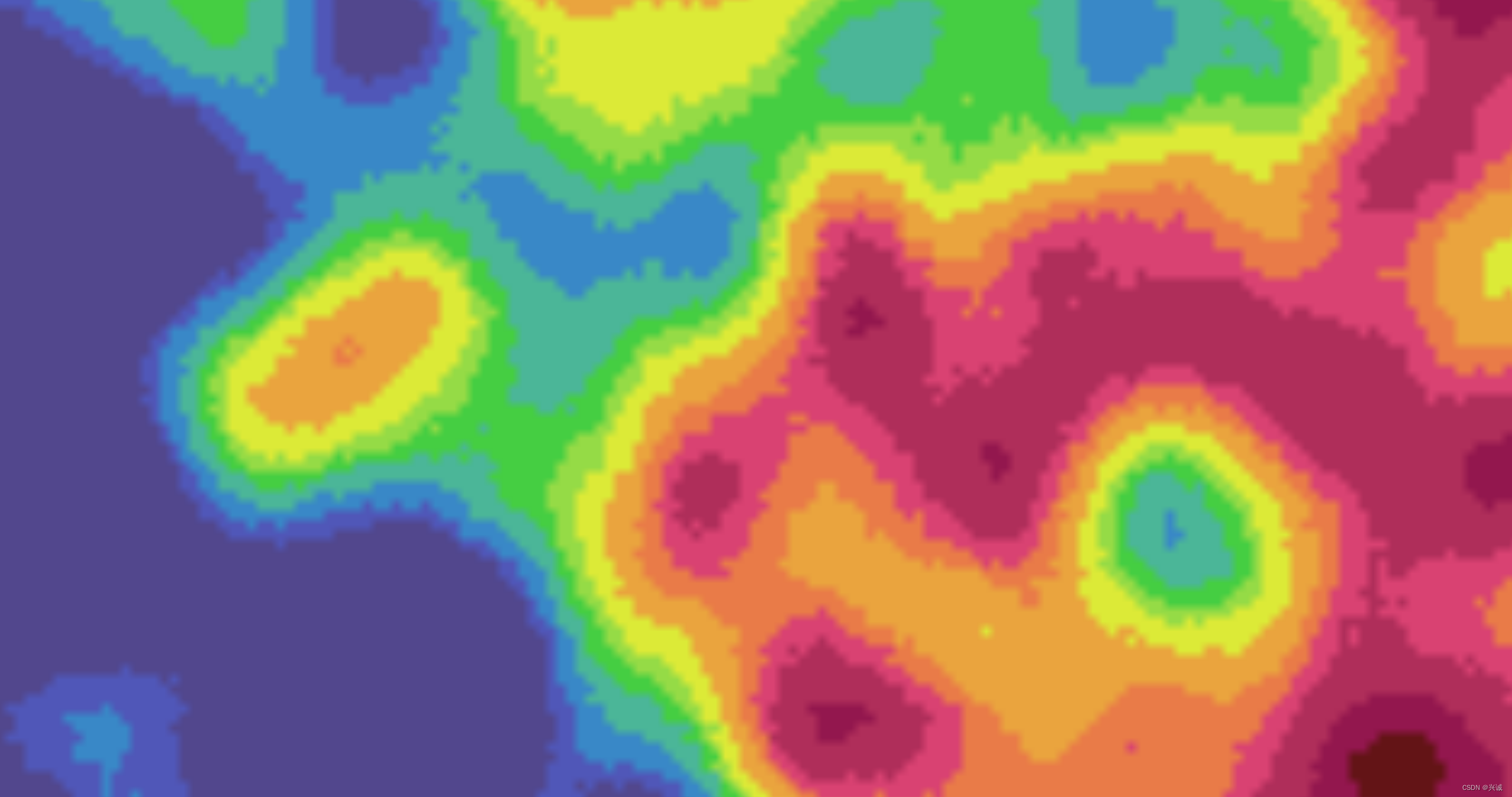
转换成图片成果
示例调用实现
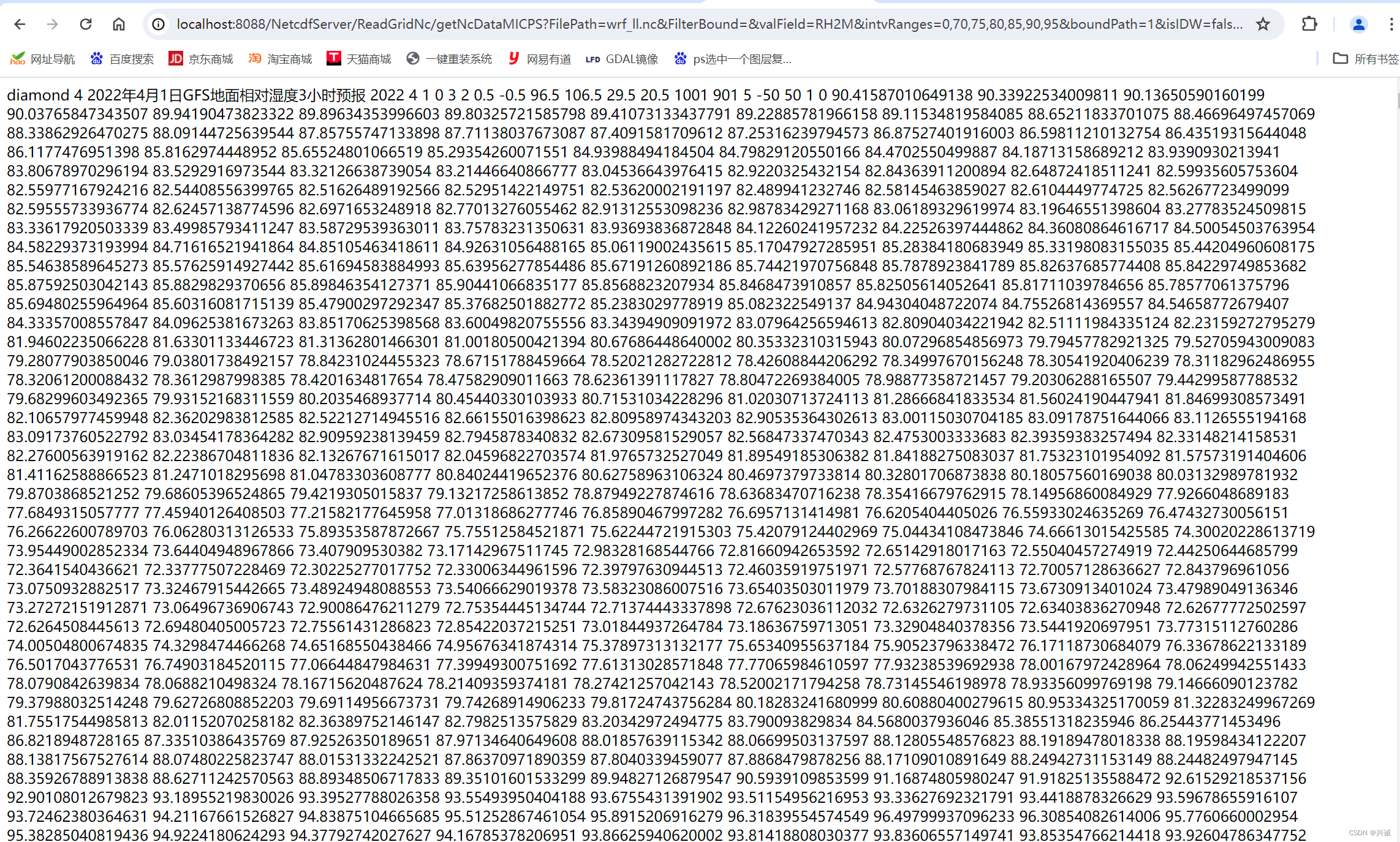
转换成矢量json成果
转换成MICPS成果
转换成CMIS成果
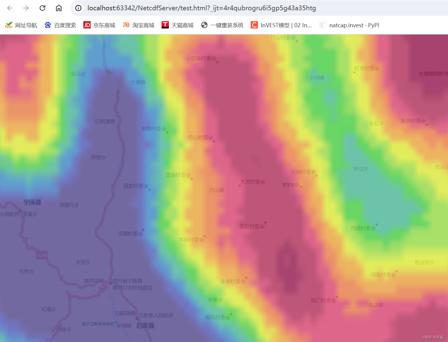
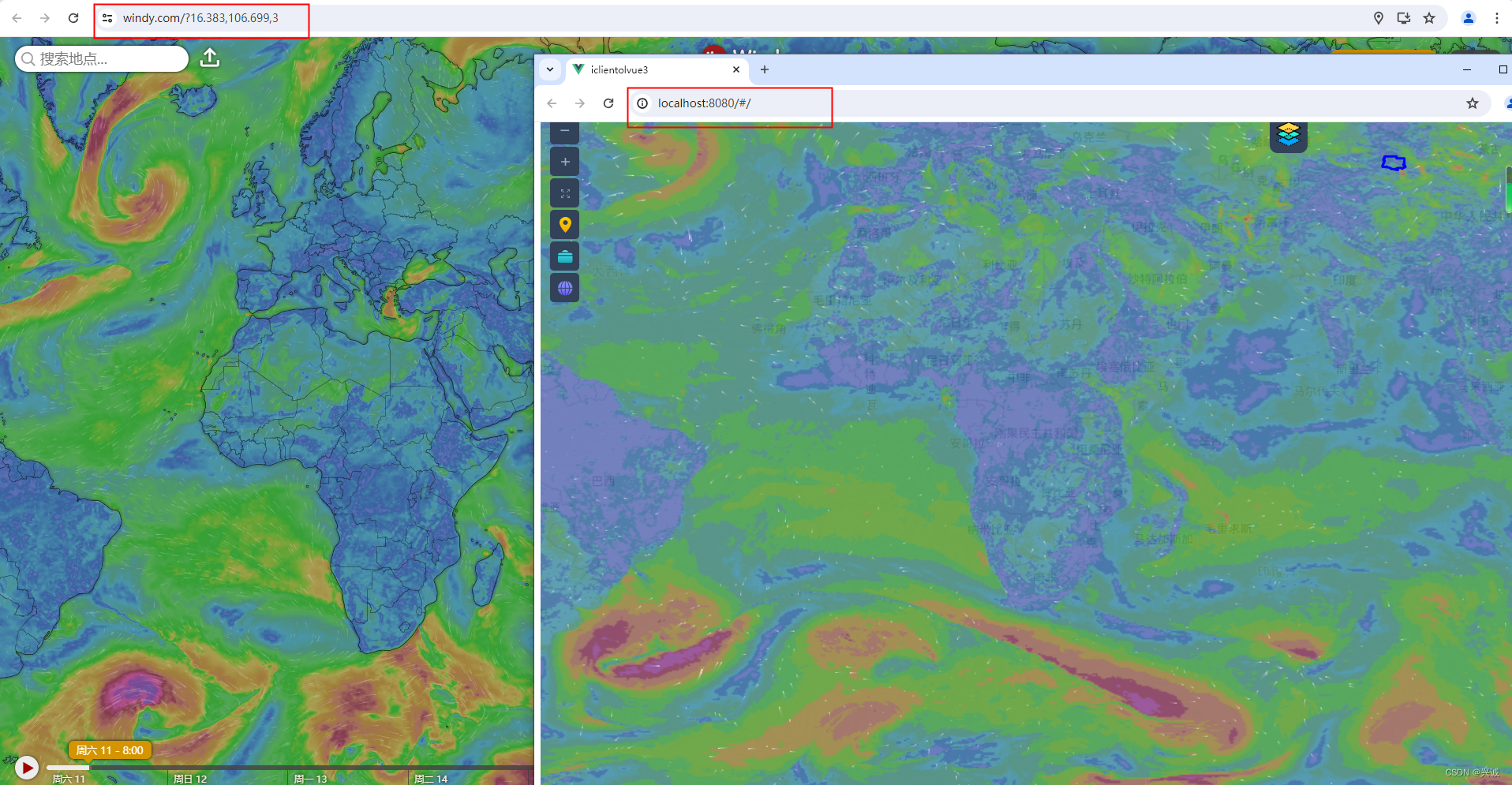
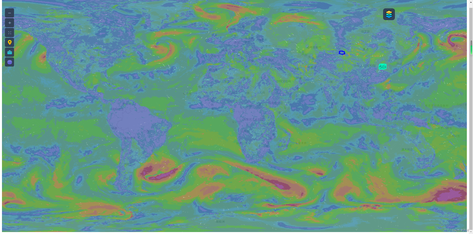
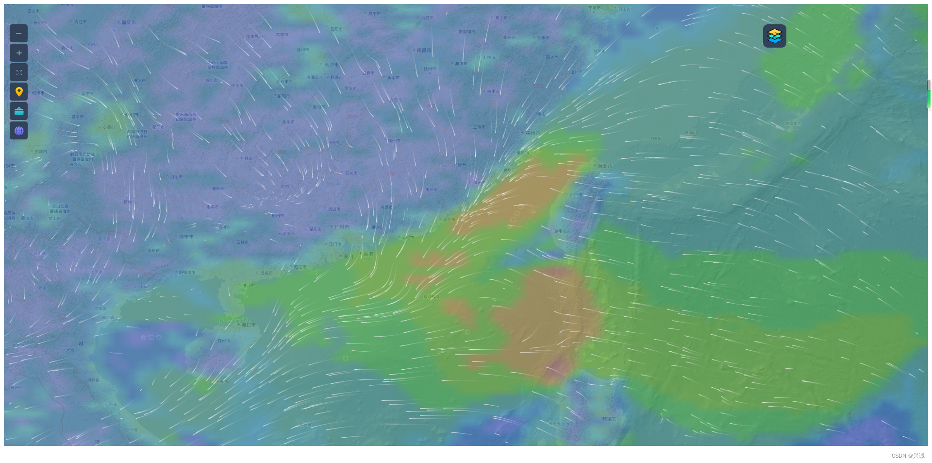
前端可视效果


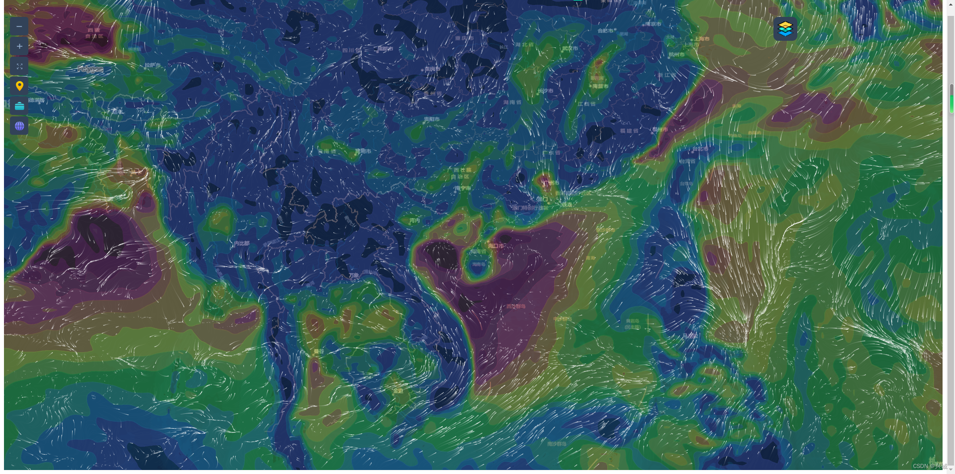
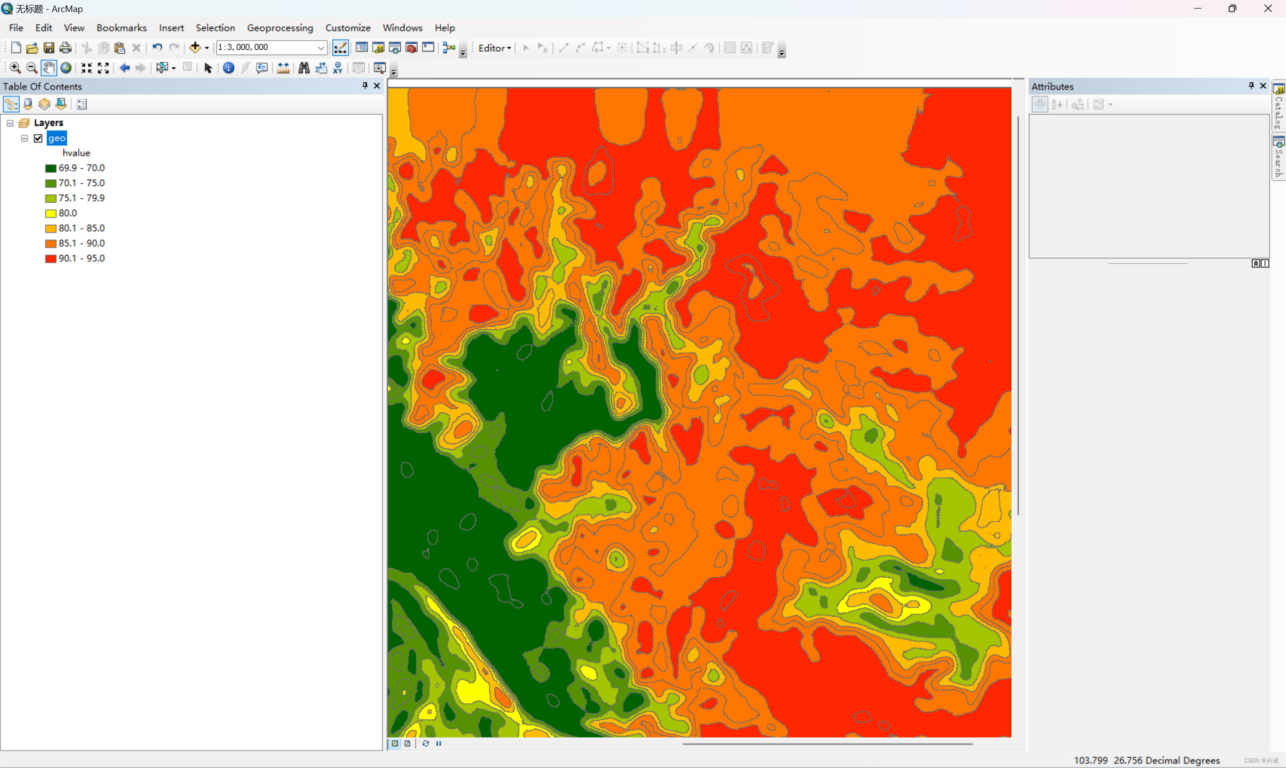
成果应用展示
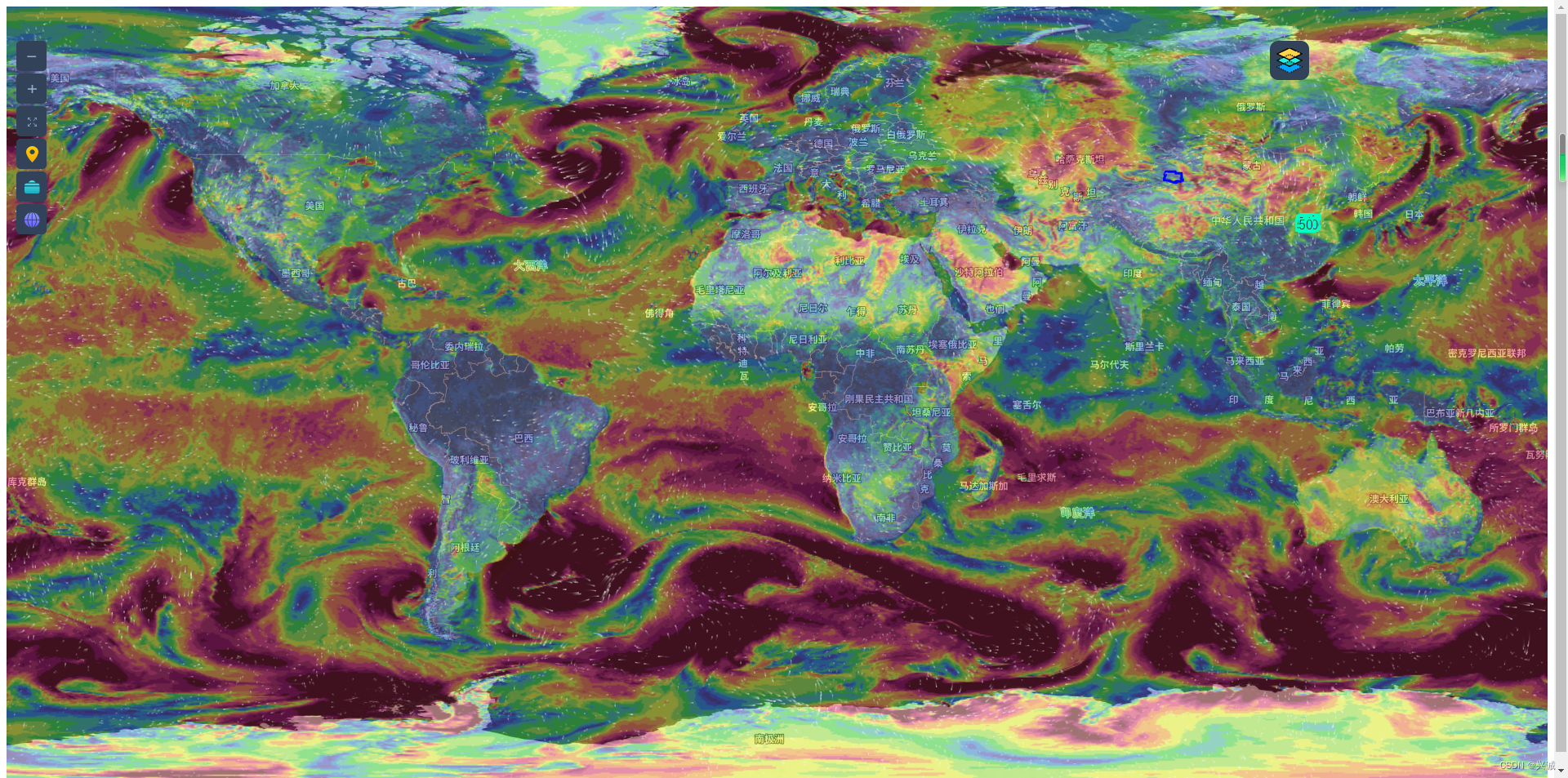
参照windy配置可视化实现
如果对您有所帮助,请点赞打赏支持!
技术合作交流qq:2401315930
最后分享一下地图下载器设计及下载地址:
链接:https://pan.baidu.com/s/1RZX7JpTpxES-G7GiaVUxOw
提取码:61cn
地图下载器代码结构设计及功能实现_地图下载管理器解析-CSDN博客


版权归原作者 兴诚 所有, 如有侵权,请联系我们删除。